
Tan Long Islet (Dragon Islet) – A Corner Of Mekong Delta
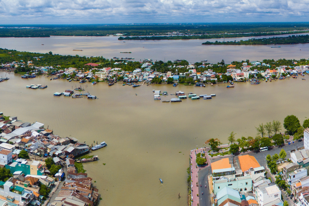
Tan Long Islet (Dragon Islet) – A Corner Of Mekong Delta Con Long – better known locally as Con Tan Long or “Con Rong” (Dragon Islet) – is a mid‑channel island in the Tien River directly opposite downtown My Tho City, Tien Giang Province. Though small compared with the surrounding plain, the islet is a compact portrait of the upper Mekong Delta: orchards pressed up against river revetments, fish cages swinging in the current, and family boatyards whose timbers smell of brine and resin. In daily usage, “Con Long” refers to the landform itself; historically, the administrative unit covering the islet was Tan Long (commune, then ward). In 2025, as part of Vietnam’s nationwide rearrangement of commune‑level units, Tan Long Ward was merged with Wards 1 and 2 to form the new My Tho Ward, but the physical island and the local name Con Tan Long remain in common use. Visitors remember the proximity first. From the My Tho riverfront, a short ferry or hired wooden boat carries you a few hundred meters across the bright braid of the Tien River; within minutes you step from city pavement into a riverscape of palms, longan trees, and low sheds where engines are stripped and planks are planed. Names and identity The islet’s names carry its meaning. “Con Long” is the geographic term. “Con Rong” – Dragon Islet – is the nickname that ties the place to river folklore. Administratively, the area was long known as Tan Long, elevated to Tan Long Ward in 2003. In tourism, Con Long is presented as one of the four neighboring islets commonly called the “Tu linh” (Four Sacred Animals): Long (Dragon-Con Long), Lan (Unicorn-Thoi Son), Quy (Tortoise-Con Quy), and Phung (Phoenix-Con Phung). Together they sit astride the Tien River where Tien Giang meets Ben Tre. Location and size Con Long lies mid‑stream right in front of My Tho. The islet’s commonly cited land area is about 273 hectares (≈ 2.73 km²), a figure repeated in multiple gazetteers. Within the “Tu linh” set, Thoi Son/Con Lan is the largest at about 1,200 ha; Con Quy is roughly 170 ha; and Con Phung a little over 50 ha. These numbers are useful for orientation and for understanding how the four islets fit together along the same reach of the river. A methodological note helps reconcile sources. When Tan Long Ward was established in December 2003, the Government’s founding decree recorded “330 hectares of natural area and 4,723 inhabitants” for the ward. The difference between ≈273 ha (the land body most people mean by “Con Long”) and 330 ha (the 2003 administrative figure) reflects boundary definitions – physical islet vs. ward delimitation that can include a belt of water surface – and the reality that river islands in the Mekong slowly shift. Both numbers belong to the record; in practice, “about 273 ha” describes the present landform, while “330 ha” is a legal snapshot tied to the 2003 upgrade. River‑made origins and early memory Delta islands accrete. In local oral history, the sandbar that became Con Rong surfaced as a small shoal around the late eighteenth century (often dated to about 1788). By 1872, the shoal had grown into an island, initially clothed in pioneer species such as river tamarisk, mangroves, and nipa palms. Later accounts mention a powerful river creature (“ong Cu”) and tell of a Dinh Tuong-era landholder crossing to claim the new ground before the French era; whatever the embellishment, the core is plain: this is a place literally made by the river’s sediment and settled by people willing to test the water. A difficult episode shadows the memory too. In 1958, during the late‑colonial/early‑Republic period, a small leprosy camp associated with Binh Duc was set up on the island and operated until 1971, after which patients were moved to Quy Hoa (Quy Nhon). The harsh nickname “Con Cui” dates from that time. In the decades that followed, poor families without land on the mainland moved out to the islet, establishing the mixed livelihoods-fishing, aquaculture, fruit growing-that define the community today. See more: Thoi Son Islet (Lan Islet) – Touch the Soul of the Mekong Administrative evolution (to 2025) After 1975, Tan Long Commune belonged to the new Tien Giang Province together with My Tho. On 9 December 2003 the Government issued Decree 154/2003/ND‑CP, upgrading Tan Long to Tan Long Ward of My Tho City with 330 hectares and 4,723 residents recorded in the decree. As part of the 2023-2025 national program to streamline commune‑level units, My Tho consolidated several wards. In 2024, Ward 7 was merged into Ward 1; official provincial reporting at the time still referenced adjacent Tan Long. In 2025, press and legal summaries reported that Ward 1, Ward 2, and Tan Long Ward were merged to form the new “My Tho Ward.” For visitors, this matters mostly for paperwork; the island itself remains the same physical place and the local name Con Tan Long endures. Landscape and environment Con Long’s landscape is the river woven into gardens. The ring levee and internal lanes have been progressively hardened; nearly all neighborhood roads are now concrete, making it easier for farm carts and visitors. Coconut palms and longan anchor most plots, interspersed with banana, jackfruit, guava, and herbs. Along the banks you will see lines of fish cages bobbing in the current; inside the creeks are clusters of low‑roofed sheds where wooden fishing boats and aluminum skiffs are maintained or rebuilt. Rivers give and rivers threaten. Like other mid‑channel islets, Con Long lives with bank erosion, seasonal flooding, and occasional salinity pulses that stress certain crops. Residents adapt by re‑vetting the banks, switching varieties, keeping floors raised, and diversifying household work. The same long‑term accretion that created the island also continues to reshape it; shoreline plots appear and disappear, and the exact contour of the island is a conversation rather than a fixed line. Economy: from river to market Aquaculture and capture fisheries. The island’s households work both sides of the water’s